The problems we have had in starting our trek early continue. Breakfast was a typical and excellent Israeli kibbutz affair – cream cheeses, grilled vegetables, humous, olives, eggs (boiled and omelettes) and all the rest – but it wasn’t until 7:30am. We were the only guests there even at that time and we were pretty tired after our very early start the day before. So we weren’t on our way from Malkiya until after 8:00am.
We left Rafi’s Forester at the Tel Hai cemetery where Yosef Trumpeldor is buried, and made our way to Kibbutz Dan to start our trek at the arch that formally marks the Northern beginning/end of the INT. There is a Museum at the entrance to Beit Ussiskin next to the start, but we decided to leave visiting that until our return in the afternoon to avoid the heat.
The walk through the morning was simply beautiful. After just a short distance we reached Tel Dan, a city mentioned in the Bible and described as the northernmost city of kingdom of Israel and belonging to the tribe of Dan. We decided to do no more than take a couple of photographs, planning to revisit the site properly on another occasion. The trail then progressed around the edge of the Tel Dan Nature Reserve with a small tributary of the Dan river crossing our path and Lebanon just a few hundred metres away to our right. We could see Lebanese villages and military listening posts on three sides and Rafi continued to display his 
detailed knowledge of the area. A few kilometres in the distance we could see Kfar Giladi, although it seemed to be on wheels as it apparently moved away as the trail weaved towards it.
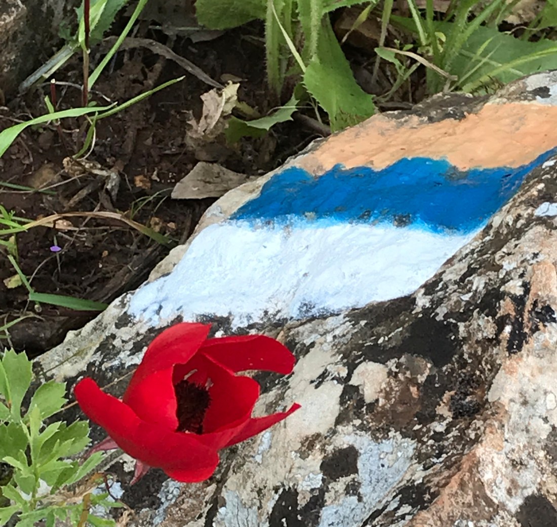
It was all pretty rural. Lots of cattle grids, though few cows, birds, clusters of beehives and a well-marked, flat and easy trail until we reached the Snir nature reserve.
The Snir is the third of the three sources of the Jordan, with the Banias and the Dan, and Ronnie and I got in free with our Israel Nature cards – even though Ronnie’s had expired. But we had not realised that at this point the INT went down the middle of the Snir river, and that meant us each paying a pretty high price for rubber beach shoes at the small shop run by a photographer from Tel Aviv.
The early part of the trail in the reserve was crowded and full of Israeli schoolkids from local summer camps, but as we walked further down the river bed of the Snir the crowds disappeared again and, as before, we felt like the only people on the INT (which, admittedly, in July is not that surprising).
 The trail through the Snir was rough and uneven, sometimes we were clambering over rocks and sometimes wading up to our knees – but the water was delightfully cool, and there was plenty of shade from the trees growing along the banks of the river. Where the INT finally left the river we ate the eggs we had taken at breakfast whilst sitting in the shade and then moved on.
At the entrance to Kibbutz Ma’ayan Baruch we found two unspent ammunition rounds and left them at the deserted entrance gate. The INT guidebook told us there is a world-class Natural History museum there but it was getting late and again over 40C and so we decided to press on. Although we were taking time out to see a lot of things along way, there is simply so much to see along the INT that it would take months to walk if you stopped to visit each of the sites.
It remained pretty easy walking, but for the oppressive heat that came up from the tarmac once we hit a paved road, and there was though a final climb up to Kfar Giladi. We arrived at the adjacent Tel Hai cemetery just as the heat of the day peaked, without the long hot afternoon hike of the day before having covered over 22km.
Kibbutz Kfar Giladi was founded in 1916 by members of Hashomer on land owned by the Jewish Colonization Association. The area was subject to intermittent border adjustments between the British and the French, and in 1919, the British relinquished the northern section of the Upper Galilee containing Tel Hai, Metula, Hamra, and Kfar Giladi to French jurisdiction.
After the Arab attack on Tel Hai in 1920, it was temporarily abandoned. Ten months later, the settlers returned. Between 1916 and 1932, the population totalled 40–70. In 1932, the kibbutz absorbed 100 newcomers, mainly young immigrants. Yet, from 1922 to 1948, between 8,000 and 10,000 Jewish immigrants from Syria, Lebanon, Turkey, Iraq, Afghanistan and Eastern Europe were smuggled into Palestine through Kibbutz Giladi, circumventing the British Mandatory ban on Jewish immigration. In an operation known as Mivtzah HaElef, 1,300 Jewish children were smuggled out of Syria between 1945 and 1948. At the kibbutz, the children were dressed in work clothes and hidden in the kibbutz chicken coops and cowsheds.
Tel Hai cemetery, where we had left the Peugeot and finished the trail that day, evoked mixed emotions in me. The story of Yosef Trumpeldor and his roaring lion is inspiring and far enough away in time not to be too personal. In contrast, the memorials to the twelve reservists who died in its shadow when hit by a Katyusha rocket in the 2006 Lebanon war is too recent; the evidence of family loss – fading flowers and photographs – tragic and extremely moving. We noticed the 12th anniversary of their deaths – their Yahzeit – was the following week
 Getting back to Malkiya was pretty easy as the other car in Kibbutz Dan was just a very short drive back. However, our intention to visit the Beit Ussisikin Museum foundered on a petty bureaucratic approach to our attempt to buy senior tickets, and so we made our way back early instead for a swim.
The Kibbutz had a a great little supermarket, and the ladies running it were extremely friendly, offering me bunches of sweet wine grapes, after which I joined Rafi and Ronnie by the pool. As Ronnie observed, there, as with all public swimming pools in Israel, loud pop music seems to be compulsory.
That evening we headed to Dubrovin’s Farm, one of the first farms in the Hula valley, for dinner. It was established by Andrei Dubrovin (1863–1967) who moved to Ottoman Palestine with his family in 1903 from Astrakhan. He and his family were Subbotniks, Russian Christians who kept seventh-day Sabbath. After their conversion to Judaism they took Hebrew names. Andrei became “Yoav”, and his wife became “Rachel”. The family farm, of 650 dunams, was located near a malaria-ridden swamp and two of Dubrovin’s sons and two grandchildren died of the illness. He eventually moved most of his family to Rosh Pinna, leaving behind his eldest son, Yitzhak, to manage the buildings, fruit orchards, and gardens.
Yitzhak bequeathed the Dubrovin Estate to the Jewish National Fund and the farm was converted into a museum that commemorates the early pioneers. Yet, in the grounds of the museum, are the ruins of a synagogue dating between the 4th and 6th centuries, highlighting the historic Jewish settlement in the region. The place is wonderfully atmospheric with an air of history, and the kosher restaurant, run by a young family, is excellent.
 climb up to Ein Koves after about 5 km. Eventually, we decided to keep the day short given the drive back – and it suited me in the end as I had a very early flight home and things to do in the house.
 After a short break, we then continued our climb for another kilometre or so to Mount Meron. Mount Meron is accessible by road and towards the military radar and listening post at the peak we came across school kids and others bussed up to the picnic area near the top.
 We hurried through the crowds there and soon found ourselves lone again walking through open rock strewn hills towards more arable – if rough land. We passed the large Druse town of Bayt Jan and a number of fields tended by Druse until we reached a memorial to a Druse Medic killed in 1992. Being further from the border, we hadn’t seen a memorial on the trail for a while – although there were plenty in Safed – and it was again sad to remember a young life cut short.


 nestling in the valley, which for sometime was probably 100 metres or more across. The scenery was delightful, and as on the first day the trail during the morning was devoid of
  people.
 Entering the Ya’ar Baram Nature Reserve we came across groups of other walkers for
  just about the first time since we started the Shvil – day trippers walking down the Dishon from Mt Meron. We found a nice spot for a relaxing lunch and set off against the
  tide of occasional walkers who filtered through until we crossed the 89 and found ourselves alone again. By now we were at over 750m but given the the trees and the valley we were in we did not see much in the way of views.
 We were looking for the car park unsure whether to go right or left along the side road (it could only be 200m one way or the other)when a youngish lady in a car stopped and said (in Hebrew) – ‘you look old I’d better offer you a lift’. This did not go down well with Ronnie in particular… indeed it took him quite a while to get over it.
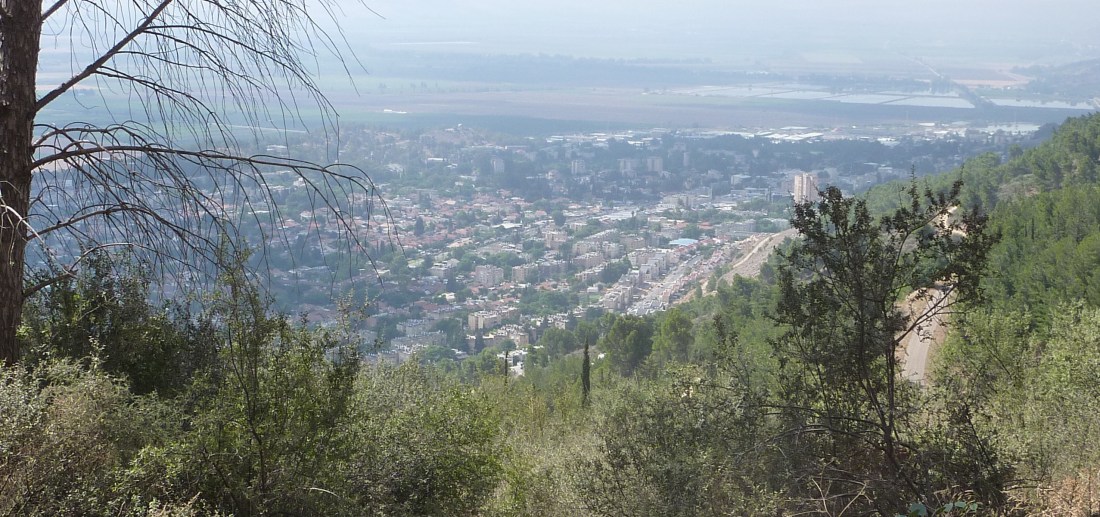
 before driving North to where we last stopped in July) and reached Yesha Fort a little before 11.00am, walking as before with spectacular views over the Hula valley. The morning weather was sunny but in the low 20s (or less) – perfect walking weather.
 the Metzudat Koach Memorial, which commemorates 28 Israeli soldiers who died during the 1948 conquest of the strategically important fort. The fort and observation point is located in the
  and made good progress as the weather clouded over but the rain held off as we stopped for lunch at the top of Keren Naftali. The views to our left over the Hula wetlands and Lake Agamon crowded with migrating birds remained magnificent. We then walked down towards the Dishon valley under greying skies and we started to get occasional threats of rain, and flurries of light showers by the time we were walking up the Dishon stream towards where we had left the car. The afternoon was muted – the land was agricultural, mainly cows and the occasional vineyards – but the views of the Hula faded to our left and there was less of historic interest to see.
 Irises starting to appear across the entire landscape, and the occasional autumn crocus that were scattered across the ground and often pocked up in the middle of the trail. I look forward to seeing the irises in heir full glory in the spring!
 the car we had left at Gesher Alma, just below Dishon. But, overall, the afternoon lacked interest compared to what had gone before, and it was raining by the time we reached the car.
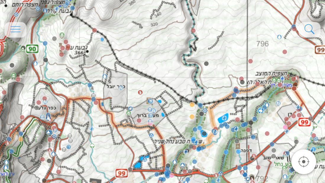
 foot hurt. At least the blister evened out the limp. Problem was my memory continued to fail – and now it wasn’t even a different thing I was forgetting each day – it was back to forgetting the walking pole.
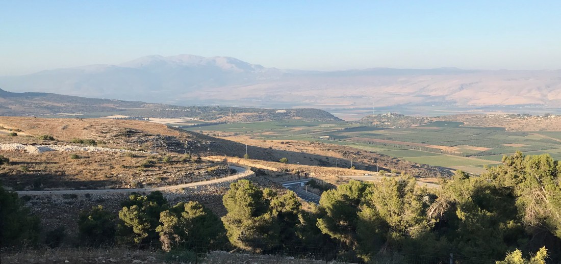
 traversing and steadily climbing led up to the Lebanese border and the Lebanese villages we could see close by to our right and behind us. Eventually Lebanon was hidden by steep cliffs and we walked in a land devoid of people – no farms, no villages, just the occasional signs of human impact in the forest – mountain bike runs, other trekking paths, abandoned iron mines, an occasional cattle grid and one cow (odd – no fields or grass), light woodland, and always on our left a steep drop and stunning views of the Hula valley.
 the sun, now high in the sky, and the heat started to become intense, but the views over the Hula to the Golan were magnificent and we made good time, finally moving off the road to a footpath in rocky but green and attractive countryside before reaching the car just before Yiftah, a somewhat

 There was a delightful peace about Ein Kiniya. Druse flags and also a variety of national flags – Portuguese, French, and others – flew from different houses, reflecting we guessed different World Cup loyalties. The village was quiet and peaceful, and an elderly farmer in the main street offered us peaches from his tractor trailer. It was the first example of what we came quickly to discover. The entire INT experience may be drawn by the trail, but it is coloured in and brought to life by encounters and experiences along the way, with people and with history.
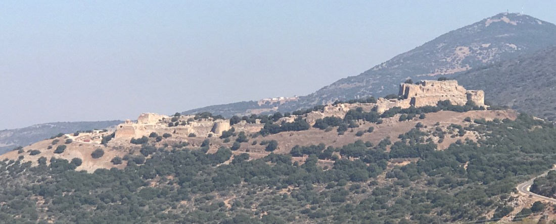
 We probably stayed too long at Nimrod. Higher up there had been a freshness to the air and a very pleasant breeze. Now it was getting hotter, the wind was dying and, as we descended the steep and rock-strewn trail from Nimrod, the temperature rose rapidly and the walk became much more strenuous.
 I hadn’t been to Banias for nearly 50 years and had forgotten how interesting it is. There is the spring, a source of the Jordan, and beautiful ponds, falls and trails. There are also the remains of a temple built by Herod the Great, of his son Philippi’s capital (Caesarea Philipi) and of a Crusader city.
 Well, I’m Anthony Angel (Tony to many friends and in business), it’s Thursday 12 July 2018 and I’m on the plane to Israel contemplating the start of the Israel National Trail (INT) on Wednesday next week.

