10 months on from my last post – and the milestone of reaching Herzliya Pituach and our home in Israel – and I have been unable to visit Israel let alone to hit the trail. With UK deaths heading toward 100,000, two million deaths worldwide (and still rising) and huge travel restrictions the COVID 19 pandemic has brought us to a place I have not experienced in my lifetime. War, plague and famine may have been with the world for millenia, but I was one of a charmed generation in the UK that had never really experienced any of them.
Israel had its challenges in managing throught the pandemic – it started well but suffered from a lack of discipline as it went on – but is now well advanced in its vaccination programme and hopes to complete it by the end of March. A great achievement. The most remarkable achievement of all though must be the speed at which vaccines have been developed and rolled out; without them the position today would be extraordinarily bleak. As I write, the UK is in its third nationwide lockdown and has been one of the most badly affected countries – healthwise and economically – in the world. The government has dithered and failed time after time to act early and decisively. With the lunacy of Brexit on top, the reverberations and consequences will last years – if not decades even if we get our vaccination rollout as planned.
So, whilst I hope to be vaccinated soon, it seems unlikely that I will be able to get to Israel until May, and getting back to the shvil may have to wait until October. Let’s hope the world will be on its way to conquering COVID 19 by then, although I fear the likelihood is that we will still be struggling in many places next winter and beyond.
Another easy hiking day along the coast, but more varied than just walking along the beach.
We left Carole and Ronnie for Netanya in two cars – we left mine at the 4C Biomed office in Netanya close to Netanya Sapir Station and the other we took to Ramat Poleg. This is familiar teritory to me. I often cycle from Herzliya to Ramat Poleg to ride back to Tel Aviv with my brother Leon who is now in Briga Towers – his third Netanya apartment in Ir Yamim.
We hiked along the Poleg stream into Poleg park and along the limestone escarpement that created the swamps to the east. The Romans drained those swamps by chiselling a channel through the ridge which is clearly visible. Walking through the orchards around Udim a local farmer told us of some irises lver a small ridge and we made a diversion to see them – along with a local class of schoolkids.
Back on the trail we took a footbridge over Route 2 just south of the Wingate Institute (named after Major General Charles Orde Wingate a religious Christian and supporter of Zionism who set up training of the Hagana) and walked through the Sharon Beach Nature Reserve of dunes and grass parallel to the coast. It was another lovely day and the route was delightful with lots of birds and flowers and occasionally spectacular coastal views.
At a couple of places along the cliff little white two seater benches overlooked the rocks and sea – apparently popular places for marriage proposals! We scrambled down and then up a deep gully at Gaash and then passed by the wealthy community of Arsuf. We ate lunch at the edge of the nature reserve (more purple irises) and made our way to Apollonia (or Arshuf) on the edge of Nof Yam.
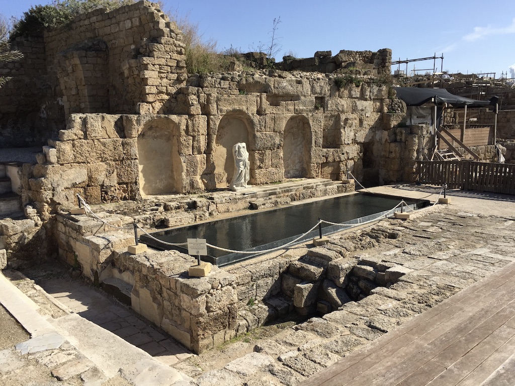
Apollonia was settled by the Phoenicians in the 6th or 5th century BC and was named for Reshef, the Canaanite god of fertility and the underworld. They produced purple dye which was exported to the Aegean. In Hellenistic times it became an anchorage town, and later a Roman villa and glass factory. It fell to the Muslim conquest in 640 and was fortified against Byzantine attacks and became known as Arsuf (Arabic: أرْسُوف ʾArsūf, Latinized Arsur). In 1101 it was conquered by the CrusaderKingdom of Jerusalem, and was a strategically important stronghold in the Third Crusade, during which the Battle of Arsuf (1191) involving Richard I was fought nearby. Richard is also said to have fought a fighting retreat down the coast from Atlit to Arsuf. The fortified city and the castle fell to the Mamluks under Baibars in 1265, when both were completely destroyed after 40 days of siege.[14] The inhabitants were killed or sold as slaves and the town completely razed. The destruction was so complete that the site was abandoned and never regained its urban character – in the 14th century the geographer Abulfeda said it contained no inhabitants.
We walked aound the site for a while and the resumed our hike past the nearby Sidna Ali Mosque just south of Arsuf which was dedicated by Baibars at the site of a saint’s tomb where he prayed for victory prior to retaking Arsuf. From there it was only a couple of kilometres to Herzliya Marina where we stopped for the day. We took a taxi to Herzliya atation and the train North, Rafi and I getting off to collect the cars and Ronnie going on to Binyamina to meet Carole.
Probably another 65 km under our belts – next stop Tel Aviv!
Day two of our three days on the Trail started early. We had a short drive to Hadera Station and did not need any variant of the two car shuffle. We planned to walk as far ar Netanya and simply to take the train back from Netanya to Hadera.
We left the car near the shopping mall and walked through the hundreds of commuters and their cars into Hadera woods. It was another perfect day weatherwise and easy hiking through and along the edge of the eucalyptus trees planted in the early 20th century to dry out the pre-existing swamp.
Everything was washed clean by recent rain and verdant, and spring flowers were abundant everywhere. There were also areas of land that are seasonally flooded with large ponds attracting hundreds of birds – many making their way north for the summer. The markers got a bit hard to find at times but we made good progress as the land became a little more rolling. To our surprise we then came across a scene more in keeping with the wild west – a couple of cowboys with their horses and a dog, and a herd of cattle they were looking after. It seemed pretty out
This slideshow requires JavaScript.
of place, though very picturesque. We chatted a bit one of them, a weather beaten guy of perhaps 55 or 60 years of age and he directed us along the trail to the underpass under the railway lines. There were a surprising number of groups of kids walking around the area given how few people we seem to encounter on the trail – even in what mist be the height of the hiking season.The red book says here: cross “USING THE UNDERPASS. DO NOT CROSS THE RAILROAD BY WALKING OVER THE TRACK“. Really
We walked for a while along the side of the track and then turned right along the bank of the Alexander River. We didn’t realise there was a diversion here to see the soft-shell turtles that live in the river (some way 50-60kg) – although Ronnie and I saw one on its own later – and we walked east towards the sea. The cormorants were out in force in trees along the bank and
after a while we came to Hirbat Samara, a late 19th century building on a small hill used by Ottoman customs officers. The purple irises here were magnificent.
We crossed Route 2 and made our way across an area of soft sand to Beit Yanai beach – where the first ship to break the British Manadate blockade – the Velos – landed.
From here the walk along the cost to Netanya was at time pretty tedious. At times cool dense sea mist rolled in from the Mediterranean and the scenery did not change. We found a large dead turtle washed up on the shore. We had lunch on the beach (I found a convenient abandoned bright yellow plastic chair) and eventually in North Netanya climbed a path up the cliff to Nitza and the Tayelet (Promenade). Walking through a seaside town felt very different – people around, pavement and tarmac, shops – but it was more interesting. As we walked south through Netanya to South Netanya the town became more modern, and the Tayelet itself is a extremely pleasant and a great feature plainly used by a large number of people.
The Southern suburbs of Netanya are still growing, and after a while we turned right through the Purple Iris Nature Reserve. This was the perfect time of year and the flowers were simply magnificent – not just the irises, but many others – the smell of Jasmine was extraordinary. I could have spent longer just admiring them, but time marched on and we went a little further on to stop our hike for the day on Poleg beacha and a well earned drink at the lively beach bar there – close by my brother Leon’s new apratment in the magnificent new Briga Towers complex.
From there, having checked emails and relaxed a bit we called a taxi to Netanya Sapir station, from where we took a taxi back to Haedera and the car.
Almost unexpectedly we seem to be so far south! The weather, though now fine, had recently been wet so we decided to postpone the Yagur to Nahal Oren leg until April and start where we left off last time, near Tishbi Winery. That is close to Ronnie and Carole’s home in Pardes Hana, and so we had the great pleasure staying there rather than at a hotel.
We met at the house for breakfast – courtesy of Carole (wonderful homemade granola) – and left a car at a shopping mall beside Hadera Station where we planned to end the day. Carole then dropped us at our starting point and we set off in sunny mild weather. Perfect.
It was a beautiful easy hike uphill past a stranded Naval patrol boat through the southern part of Ramat Hanadiv, the beautiful location of the Memorial Gardens with the tomb of Baron Edmond James de Rothschild. A strong Zionist, his large donations lent significant support to the movement during its early years, which helped lead to the establishment of the State of Israel.
Ramat Hanadiv was formerly the location of Umm el-‘Aleq, a small Arab village where in the 19th century a farmstead (Beit Khouri) was constructed by the Christian Arab family of el-Khouri from Haifa. French Baron Edmond James de Rothschild purchased the land from the el-Khouri family as part of his project to establish Zichron Yaakiv which he had previously funded in 1892. The Jews coming during the Third Aliyah in 1919 toUmm el-‘Aleq changed its name to “Ummlaleq” (“the miserable one”); their diaries recorded conflicts with the evicted Arabs, as well as malarial mosquitoes proving to be an impediment to settlement within the region.[1]
Baron Rothschild died in 1934 at Château Rothschild (Boulogne-Billancourt). His wifeAdelaide died a year later on 29 December 1935. They were interred in the Père Lachaise Cemetery in Paris until April 1954 when their remains were transported to Israel aboard a naval frigate. At the port of Haifa, the ship was met with sirens and a 19-gun salute. A state funeral was held with former Prime MinisterDavid Ben-Gurion giving the eulogy following which Edmond de Rothschild and his wife were re-interred in a crypt in the Memorial Gardens of Ramat Hanadiv. For his Jewish philanthropy Baron Edmond became known as “Hanadiv HaYadu’a” (Hebrew for “The Known Benefactor” or “The Famous Benefactor”) and in his memory his son bequeathed the funds to construct the building for the Knesset.
Shaldug – Kingfisher
The trail passed Ein Tzur and a number of ancient ruins including a Roman bathhouse before climbing climbed gently through lightly wooded rocky hillsides with a spectacular display of spring flowers that were to be a highlight throughout our three days on the trail.
This slideshow requires JavaScript.
Further on we came to Horvat Akav, the hightest point in the southwestern part of the Mt. Carmel cliff. The archaeological findings of this agricultural compound have uncovered three periods of settlement : the ruins of a 1st century BCE second temple era Herodian manor house, a Byzantine farm (4-7th cent. CE) and from the medieval period. The views were simply stunning.
From here we made our down a rocky and at times steep descent to the coastal plain, clambering over the high speed
railway track as the trail underpass was heavily flooded. We walked alongside Nahal Ha’Taninim (Crocodile River) where theheavy rains in recent weeks had turned areas of normally dry land into temporary swamps and lakes. It is probably rare to gain an insight into how the area must have looked at the time the Cabra swamp was infested by crocodiles – and easy to imagine.
This slideshow requires JavaScript.
We took a (dry) underpass beneath Route 4 to Beti Hananya and our first glimpse of the High Level aqueduct leading to Caesaria. In fact, three aquaducts served Caesaria, two from the north, named the High level and the Low level aqueduct, and a third one – a pipe line – that came from the south.
The High level aqueduct, constructed in the 1st century CE, started at the Shuni spring located about 7 km north-east of the city and passes Beit Hananya and along the beach north Caesaria. Its head of water when reaching Caesarea was 8.5 m, with long sections supported by arcades. The average effective delivery of the High level aqueduct was 300 cubic metres (300,000 litres) per hour – enough for a city of 50,000 inhabitants. Indeed, its capacity of 145 liters per day per person is similar to the consumption in modern cities of developed countries.
Ten inscriptions have been found attached to the High level aqueduct. Nine are in Latin and one is in Greek, the latter referring to repairs made by order of the Roman proconsul of Palestine in / after 385 CE. The nine Latin inscriptions mention three Roman legions active in repairing (not the actual construction) the High level aqueduct during Hadrian’s reign, about 130 CE: five inscriptions refer to Legio X Fretensis (of the sea strait), two to Legio VI Ferrata (ironclad), one to Legio II Traiana Fortis (valiant), and another one is uncertain. The prominent one attached to the aqueduct close to Beth Hananya comprises of legionary insignia of the Xth Roman legion and a tabula ansata (table with dovetail handles) with the text: IMP CAES / TRAIANVS / HADRIANVS / AVG FECIT / PER VEXILLATIONE / LEG X FRETE or: Imperator Caesar Traianus Hadrianus Augustus [caesar Hadrian 117 – 138 CE] made [this] by means of a detachment of the legio X Fretensis.
We were so impressed walking beside the aquaduct west from Beit Hananya we went too far and had to double back to get back on to the Trail. We passed under Route 2 bent double (hard on Rafi given his height!) to Jisr al-Zarqa, a large costal arab town and stopped for lunch beside the small pcturesque fishermen’s village nearby.
From now, heading South, we were going to spend a lot of time until we reach Tel Aviv walking along the sea shore. Fortunately the rain had left large areas of firm sand and the camber was slight, and so it was easy walking and not too far until we reached Caesaria itself – entering through the Northern service entrance (and by-passing the pay booth… ) to stop for refreshments. Although this was not a time to go round the ruins, and we had all been there several times, it is a fascinating site well worth a half day visit.
The ancient city of Caesarea Maritima was built by Herod the Great about 25–13 BCE as a major port. It served as an administrative center of Judaea Province of the Roman Empire, and from 13 BCE as the capital of the ByzantinePalaestina Prima province. Herod built a palace here with a pool jutting out to the sea and it was the official residence of Roman procurators and governors, incliding Pontius Pilate. During the Muslim conquest in the 7th century, it was the last city of the Holy Land to fall to the Arabs. The city degraded to a small village after the provincial capital was moved from here to Ramleh and had an Arab majority until Crusader conquest. Under the Crusaders it became once again a major port and a fortified city. It was diminished after the Mamluk conquest.[4] In 1884, Bosniak immigrants settled there establishing a small fishing village.[4] In 1940, kibbutz Sdot Yam was established next to the Bosniak village. In February 1948, the Bosniak village was conquered by a Palmach unit commanded by Yitzhak Rabin, its people already having fled following an earlier attack by the Lehiparamilitary group. In 1952, the modern Jewish town of Caesarea was established near the ruins of the old city, which in 2011 were incorporated into the newly-created Caesarea National Park.
Up until Caesaria it had been a magnificent few hours hiking across the southern tip of the Carmel mountain range, down to the coast, along the beach following the quaduct, in perfect walking weather with wonderful views and beautiful flowers.
From here on, I’m afraid, the day became more of a slog. We trail took us inland through sand dunes south of Caesaria (not easy hiking), and them along the side of Route 2 before walking the last stretch of the Hadera River beside the power station to the sea. After crossing a bridge over the River it was a long boring straight stretch to Givat Olga. There, the Trail has not been adapted to cope with extensive construction work, so it took a dash from across the turn off from Route 2 to make it to the shopping centre car park where we had left our car, arriving in time to drive the short distance back to Carole and Ronnie – in time for a whiskey in the garden at sunset before dinner…
The weather forecast did not bode well for later in the day – and we did not want to run into the problems we had the previous day. It was also the last of our three days hiking and we wanted to be back at a reasonable time – I planned to visit 4C Biomed in Netanya. So Rafi proposed a particularly short day ending at Route 70. That seemed rather unambitious and after some negotiation we agreed to leave the car a little further on at Zikhron – but on the basis we would walk on and take a taxi back if we made good time.
So we left early, had a quick breakfast at the petrol station we had reached the previous evening and started our walk at around 08:30 from the National Park site on Route 7021 near Kerem Maharal (and the Amphorae Winery) – having checked they didn’t lock the gates at night and we could safely leave a car in the car park there.
We passed early on a memorial for a fallen young soldier and ,after a short rock scramble, the trail though very muddy gave way to relatively easy hiking. At times we had to make detours through thick undergrowth to avoid small lakes of water straddling the path (at one point after an hour or so of relatively constant detours this began to get rather wearing) but the weather slowly improved and we made excellent time. By 11:00 we were approaching Route 70, and just above it I spotted a large fox enjoying the sunshine. There were impressive infrastructure works around there too, with new roads and terraces for a housing development in Furedeis. We passed a number of stone quarries nearby.
We pressed on across the 70 and climbed steadily up a good trail towards Zikhron Yaakov. After maybe 3 or 4 km the trail levelled out and it was easy walking with sunny spells, so we decided to continue past Zikhron (the trail passed a little to the east of the town with the houses on a ridge above us).
By 2pm we had reached the Tishbi Winery and decided to stop for lunch there. It would have been easy to press on and finish the rest of the recommended stage – but, hey, this was a rare opportunity for a great kosher lunch with wine 200m off the INT!
The food and wine was excellent and although they messed up on my order – giving my Pizza to someone else – they more than made up for the error by giving us the entire meal on the house! That Rafi knew someone there may have helped…
As we finished the rain started to fall very heavily. Any thoughts of continuing (if there there were any) died and we took a taxi back to the car. It had been a really nice day, but perhaps the least interesting part of the trail so far. Of course that does not include Zikhron Ya’akov itself, a fascinating place.
Zikhron Ya’akov was founded in December 1882 when 100 Jewish pioneers from Romania, members of the Hibbat Zion movement, purchased land in Zammarin. The families came from Moineşti in Moldavia and a central merit in organising the move belongs to Moses Gaster, scholar and early Zionist. The difficulty of working the rocky soil and an outbreak of malaria led many of the settlers to leave before the year was up.[3]
In 1883, Baron Edmond James de Rothschild became the patron of the settlement and drew up plans for its residential layout and agricultural economy. Zikhron was one of the first Jewish agricultural colonies to come under the wing of the Baron (along with Rishon LeZion and Rosh Pinna), who renamed it in memory of his father, James (Ya’akov) Mayer de Rothschild.
To accomplish his first objective, Baron de Rothschild brought in planners who designed and allotted housing lots along the main road for the use of settlement farmers. Each lot included a house facing the street, a long interior courtyard and a rear building for storing agricultural implements. The French-inspired architecture included tiled roofs and painted wooden windows. Each farmer was given a salary and placed under the direction of Elijah Shaid, the Baron’s clerk. The Baron also commissioned the construction of the Ohel Ya’akov Synagogue, named after his father, to serve the town. Sparing no expense to build the edifice, the synagogue features a majestic ark made of white marble. The synagogue opened in 1886 and has conducted daily prayer services continuously to this day.
Following a number of economic failures, in 1885 Rothschild helped to establish the first winery in Israel, Carmel Winery, together with a bottling factory, in Zikhron Ya’akov. This was more successful economically although it was initially short-lived as in 1892 the grapevines succumbed to phylloxera, a type of parasite. After a brief set-back, American seedlings which were resistant to phylloxera were grown and the winery began to flourish. Today, the winery remains in action, as do the huge wine cellars that were carved into the mountain over a century ago.
In 1894, Jewish and Arab workers earned a wage of six piastres working in the plantations, but Jewish workers also received a supplement of four piastres from a charity fund. When Rothschild withdrew his financial support from plantations in Palestine in 1900, the subsidy was discontinued. Jewish workers were quickly replaced by Arab ones, used to being paid the lower wage.
In 1954, the remains of Baron Edmond de Rothschild were reinterred in Zikhron Ya’akov.
Zikhron Ya’akov came to fame during World War I for the establishment of the Nili spy ring by Sarah Aaronsohn, together with her brothers, Aaron (a noted botanist) and Alex, and their friend Avshalom Feinberg. The group volunteered to spy on Ottoman positions and report them to British agents offshore. In September 1917, the Ottomans caught one of Sarah’s carrier pigeons and cracked the Nili code. In October, they surrounded Zikhron Ya’akov and arrested Sarah and several others. After four days of torture, they planned on transporting Sara elsewhere, she requested to be taken home to change her clothes and shot herself with a pistol hidden in her bathroom and died after several days. Sara shot herself in the throat, leaving her unable to speak, in order to avoid releasing classified information. The Aaronsohn House–Nili Museum recreates the history of this period.
The population increased dramatically in the early 1950s, after the establishment of the State of Israel. Between the 1960s and 1990s, the population remained constant with about 5,000 inhabitants. Since then it has grown rapidly to over 23,000.
The original Carmel-Mizrahi Winery continues to make wine in Zikhron Yaakov. The town draws many tourists attracted to its picturesque setting and historic city centre whose restored main street of landmark buildings, called Derekh HaYayin (“Path of the Wine”), houses coffeehouses and boutique shops selling locally-made crafts, jewellery, and antiques, especially on the town’s famous “Midrachov” (Rechov haMeyasdim — Founders Street).
Our first evening in Beit Oren we had eaten at a pleasant Italian restaurant on the outskirts of Haifa. For our second evening we decided to go to the German Colony and enjoy the nightlife. So, a little bit about the German colony and Haifa…
German colony in Haifa, 1875.
The German Colony (HaMoshava HaGermanit) (Hebrew: המושבה הגרמנית) was established in Haifa in 1868 by the German Templers. It was the first of several colonies established by the group in the Holy Land. Others were founded in Sarona (then near Jaffa, now in the heart of Tel Aviv) Jaffa, Galilee and Jerusalem. They played an important role in bringing European infrastructure and agricultural techniques to Palestine.
Old Templer house in German Colony German colony of Haifa
The Templers built their colonies in keeping with strict urban planning principles and introduced local industries that brought modernity to Palestine, which had long been neglected by the Ottomans.
The population of the German colomy in Haifa fluctuated between 300-400 settlers between 1870 and 1914. Employing modern farming methods, the Templers introduced soil fertilization, better methods of crop rotation and new crops such as potatoes. They imported agricultural machinery and engaged in “mixed farming,” combining dairy farming and field crops.
Registering the land was problematic due to back taxes and local boundary disputes, which sometimes turned violent. The Templers thus abandoned farming in favor of industry and tourism. They built hotels, opened workshops and established an olive oil soap factory. The affluent German colony stood out in its poor surroundings. By the end of the Ottoman era the colony had 750 inhabitants, 150 houses and dozens of businesses.
When in World War IGeneral Allenby conquered Palestine from the Ottomans, the German colonists were regarded as enemy aliens. Many of the colonists were recruited for the units of the German Imperial Army, which fought together with the army of the Ottoman ally against the British conquest. The Britons entered Haifa and the colony only after the end of the fighting. Thus the colonists in Haifa were not deported to Egypt, as were the colonists of other, more southern colonies (Jaffa, Rephaim, Sarona, and Wilhelma), which happened to lie in the battle fields.
In 1937, 34% of the Templers were card-carrying members of the Nazi party. On King George VI‘s Coronation Day in 1937, all the Templer colonies flew the swastika flag. At the start of World War II colonists with German citizenship were rounded up by the British and sent, together with Italian and Hungarian enemy aliens, to internment camps in Waldheim and Bethlehem of Galilee. 661 Templers were deported to Australia via Egypt on July 31, 1941, leaving 345 in Palestine.
Many of the old Templer homes have been restored in recent years. Buildings along Ben-Gurion Boulevard (the main thoroughfare) have been turned into cafés, boutiques, hotels, and restaurants, one houses the Haifa City Museum, and the colony has become a center of Haifa nightlife.
As for Haifa today, although Israel’s third city with around 250,000 inhabitants, a major port and its scenic location making it an excellent place to live, economically the city has been in relative decline over past decades. More recently major infrastructure investments in the North have improved access, but still the city seems a bit of a (pretty) backwater. Efforts are being made to change this, with hi-tech centres feedingoff the Technion University, and one of Haifa’s great assets is its multicultural nature; it is regarded as a haven for co-existence.
Israeli Jews comprise some 82% of the population, almost 14% are Christians (the majority of whom are Arab Christians)[87] and, some 4% are Muslims (of which 20% are Ahmadis[89]). Haifa also includes Druze and Baháʼí communities. Haifa is the center of liberal Arabic-speaking culture, as it was under British colonial rule. An active Arab cultural life has developed in the 21st century.
Haifa’s diversity was very much on display when we went to what I think was a Druze restaurant in the centre of the German Colony. The streets were festooned with light for the Chanukah/Christmas season and the roundabouts with Hannukiot, Christmas trees and Moslem/Islamic crescents. The pavements were crowded with people of all denominations and none, the atmosphere happy and light-hearted and the noise complemented with the tunes of musicians on street corners. It was just the food that spoilt a wonderful evening…
‘FOURTEEN KILOMETRES! Is that ALL? What were you doing?’ I hear you ask. ‘It wasn’t even bad weather!’ Well, I’m not sure I can it explain either – except that terrain that looked pretty level on the map was anything but benign in reality.
Our first problem was, indeed, under-estimating the terrain (Rafi insisted his book called it an ‘easy day’). As we had decided to postpone the leg from Yagur to Nahal Oren to a later trip (because it involved a climb that was dangerous in the wet) we thought we had time for a leisurely breakfast at an Arcaffe in Haifa, left a car on Route 70 between Faradeis and Zichron Yaakov, and didn’t get under way from Nahal Oren until around 9:45am. But we didn’t really think too much of it with Rafi’s assurances ringing in our ears that this was going to be a easy day with around 22 km to cover in 6 or 7 hours.
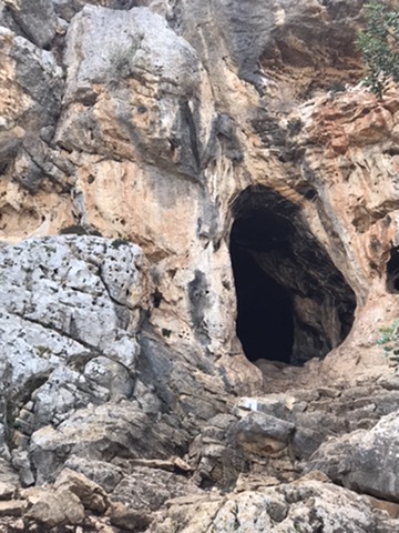
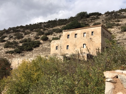
We started with 169 steps up to the Etzba cave, but it was not a hard climb up to the entrance. Along the path is a small British post, which was constructed here during WWII in order to protect the entrance to Nahal Oren, one of the roads to the centre of the Carmel. This fortification was part of the “Masada” plan, conceived in order to make the “last stand” on Mount Carmel if German forces broke the British defence lines in Egypt. There are a number of British-mandate period structures in this area, such as on the west side of this ridge, and on other areas of Mount Carmel.
The cave is one of a number in the Oren valley inhabited by prehistoric man. Indeed, the Carmel Mountains are full of caves occupied by prehistoric man through several periods starting a half a million years ago up to around 9,000 years ago.
We were later to pass a fine museum giving much more detail – but were so far behind schedule we will need to go back another time. Nevertheless, at this stage the terrain was easy as we walked to Ein Hod and then turned due South parallel to the coast, with magnificant views out to the coast and beyond.
From then on, however, the walking became increasingly slow. It wasn’t terribly difficult, but it was painstaking and arduous as the ground was broken and rocky; it was hard to make more than a couple of kilometres an hour. Frustratingly just a couple of hundred metres or so to our right was the coastal plain with smooth dirt roads and Route 4 – easy walking. But not for the first time the INT took a more challenging route, occasionally moving inland to take in the valleys carved by small streams running to the sea. Like good shvilists, we stuck to the trail.
At one point we suddenly came across an IDF reconnaisance unit dug in to our left on a training mission. From the trees in the river valley in front of us there was a great deal of noise and shouting and we hurried on out of the firing line!
There were, surprisingly given the time of year, many more wild flowers than I had expected dotted among the rocks and adding colour to the patches of grass, and in the ptrotected valleys we could see bee hives.
We also continued to have fine views of the coast as the trail climbed ridges of higher ground from time to time between river valleys. The rocks were slippery where wet and sharp-edged – evidence of underwater volvanic activity when the Mediterranean Sea covered the area. Eventually, we arrived at Nahal Mearot an important pre-historic site with evidence of over 500,000 years of human activity with Human culture from the Acheulian (500,000 to 200,000 years ago), Mugharian (150,000 to 100,000 years ago), Mousterian (100,000 to 40,000 years ago), Aurignacian (40,000 to 12,000 years ago) and Natufian (12,000 to 9,000 years ago) eras.
The Caves of Nahal Me’arot / Wadi el-Mughara (“Caves Creek”), are a UNESCO Site of Human Evolution. The four UNESCO-listed caves are:
The four caves were proclaimed a site of “outstanding universal value” by UNESCO in 2012. They are protected within a nature reserve.
The caves were used for habitation by hominins and prehistoric humans and contain unique evidence of very early burials, at the archaeological site of el-Wad Cave in the Nahal Me’arot Nature Reserve.
We wanted to take time to see the museum but concluded that will need to be another trip. We had too far to go to the car to stop, so after a brief lunch and a drink at the museum cafe we pressed on.
We passed Sheikh Amir’s Tomb and later reached the Ofer lookout and observation tower. The views all around were magnificent. By now though it was clear we would not make the car before nightfall and we decided to stop at Route 7021, near Kerem Maharal, and to hike along the road west to Route 4 (where there was a petrol station marked on the map) and to call a taxi. So, that is what we did. By now the route was becoming easier and we made good time to the junction. The taxi came quickly and we made our way back to Beit Oren.
It was around then that Ronnie told me that Rafi had disclosed he made an error. The 22 km trek he had identified was easy enough to complete in the recommended time – but that time was 12 hours! We had less than 7 hours of daylight from when we started…
I then checked my maps. As you will see from the map for Stage 14 to 15, these actually only recommend doing the 14 km to Kerem Maharal in a normal hiking day because it is so arduous, especially in winter. I didn’t feel so bad then…
The heavy rain on 10 December raised the question of what to do the following day? We had planned to do the leg from Yagur to Nahal Oren, but that involves a steep climb from Yagur to Rom Carmel – a climb that Rafi’s book strongly advised should not be attempted after (or during) heavy rain. We alread had experience of how slippery muddy boots could be on wet rock and so after a discussion we decided to skip that stage and to tackle the one in his book for the dayafter – from Nahal Oren to Route 70 between Furadeis and Zichron Yaakov instead.
We also put in our diaries a couple of extra walking days in April and agreed to fill in the missing leg either on our walk in early March (weather permitting) or in April. This seems eminently manageable as we are walking ever closer to Ronnie’s and my homes where we plan to stay for the next two trips.
Unfortunately, things still did not go as planned…
We can measure the progress we are making by how much less time it now takes to reach the drop off point for the car. Kibbutz Yagur where we planned to finish the first day’s walk was barely an hour’s drive from my home and I met Rafi and Ronnie at the shopping mall just outside the kibbutz at 7:30am. Nowhere nearby for breakfast, so we grabbed something (and in my case snacks for lunch) at a pretty uninspiring petrol station on the way to the day’s start at Alon Hagalil.
We strode off in pretty decent weather – hazy sunshine and mild. The forecast was for rain later (and again on Thursday, with Wednesday being fine) and so we needed to make good time in the morning to cover the 24 km to Lagur.
All went well for about 45 minutes.
I was striding ahead with Ronnie and Rafi trailing perhaps 100 metres behind. The trail ran along the side of a field uphill to a forest where, after a short clamber over rocks the trail split. I could see INT markers over to the left and followed a quiet pine leaf covered trail upwards with occasional rocky out crops and markers every 25 metres or so. After perhaps 5 or 10 minutes I stopped for Ronnie and Rafi to catch up. They didn’t. After about 10 minutes I called; I called again; I blew my whistle. Silence reigned (apart from the occassional pair of F15s on manouevres). After a while I rang them on my mobile. It turned out they had turned right at the junction and lost the trail. I suggested they go back to the junction and turn left (rule 1 – if you lose your way on the trail, go back to the last marker you passed) but they decided to ‘save time’ going over a small hill to rejoin the trail on the other side.
We finally met up around an hour or so later. Scrambling through woods in roky terrain across country is hard work. My whistle – even when they were in earshot and we ended up 2 or 3 km apart – could not be heard as gunfire in their army years had led to high pitch hearing loss. I sent an email with my exact position and gave an exact map reference (to the maps I had downloaded, laminated and distributed at the beginning of the day), but Rafi’s phone froze so he could not work out where he was. They ended up too far north and in the woods it was hard to see landmarks. When we could each make out a line of date palms or a farmouse on a hill, or a cliff, it turned out there were several of each and we never seemed to be looking at the same landmarks. Aargh! We got back together again in the end but managed only about 3km in the first two hours…
We pressed on and kept up a good pace as the sun broke through strongly and we stripped down to T shirts. The countryside was pretty and the path good as we walked beside a stream to Hanezirim Mill (Monks’ Mill, owned by the Vatican). But even that was less than half way to Yagur, sunset was only 3 or so hours away and the weatehr showed signs of getting worse.
By 2pm it was raining, and the rain was soon heavy. We change into our waterproofs by the Alonim Nature Reserve and pressed on, but some of the climbs were steep, rocky and increasingly slippery as we crossed Route 762 and entered the Shaar Haamakim Nature Reserve. The problem was exacerbated because there were some pretty muddy areas too, and the mud you picked up on your boots meant no grip on the rocks.
It was hard work, and coming down the steep descent towards the Kishon Valley and
Kibbutz Yagur
Yagur was tricky. Fortunately we hit the valley well before dark, but dusk fell as we walked through the religious settlements of Kfar Hanoar Hadaty and Kfar Hassidim, under Route 70 and to Yagur.
We were muddy. We hosed our boots down in the stables there, collected the other car and made our way to Beit Oren (‘home of the pine’) for the night
In 1934 a single Arab house stood on the site of what is today Beit Oren. It was purchased with the surrounding lands, settled by a group of 15 Jewish workers, and served as a watch tower and camp. The workers intended to build a city and name it Ya’arot HaCarmel, but a number were killed when the site was attacked during the 1936 Arab Revolt.
The kibbutz was founded in 1939 by immigrants from Poland and Russia, part of the Hebrew Socialist Youth movement. Over time these were joined by other groups from Dror and Aliyat HaNoar, as well as by a group from Kibbutz Ma’agan Michael.
During the Mandate era the kibbutz served as a Palmach base for underground activities against the British. On 9 October 1945, a Palmach unit set out from Beit Oren to free 208 illegal immigrants detained at the Atlit detainee camp. After overcoming the guards, the freed immigrants were led past Beit Oren to Kibbutz Yagur, where they were hidden from the British. The attack was the first anti-British action undertaken by the Palmach.
When Ronnie was 11 in 1961 his mother and her new husband brought him here for their honeymoon.
During the 1980s Beit Oren suffered severe financial problems and many of the middle aged members left, leaving the senior members with debts and no income or means of subsistence. The kibbutz movement stopped financial support to the kibbutz, and a group of young individuals were brought in to make fundamental changes. In 1999, eight members of Beit Oren petitioned the High Court of Justice to abolish the classification of Beit Oren as a kibbutz and classify it as a community village.
Beit Oren after 2010 fire
Beit Oren suffered extensive damage in the 2010 Israel forest fire, which claimed the lives of 41 people and burnt thousands of acres of forestland.
In 1942, Beit Oren opened a guest house which became popular among Europeans seeking respite from the summer heat in other parts of the country. The Beit Oren Hotel, still in operation, was where we stayed. It has 30 rooms, a yoga center and a swimming pool.
We settled into our typical kibbutz rooms and then drove into Haifa for dinner. As we descended from the Carmel Mountains the nightime views of the city – as far as Akko – were spectacular.
Although the UK general election is on Thursday 12 December 2019 – when I plan to be hiking the trail – I will be voting by post to ensure my voice is heard. That is, if I could only work out what voice that is. I have never felt so disenfranchised as I do now.
The UK Prime Minister, like the US President, has turned lying into an art form. It has reached the stage where neither actually seems conciously to realise they are lying; they just say what is convenient at the time and, on that basis alone, claim it must be true even when it is demonstrably false. So, it is absolutely clear Brexit will be a long term disaster for the UK economy whilst Johnson claims the opposite. It is also absolutely clear that we cannot get an EU trade deal in 2020, and Johnson will not ask for an extension of time in June as he would need to. So we will head for the worst kind of Brexit – a no deal Brexit with consequent chaos. You may want Brexit for other reasons – but acknowledge the economic and practical truth.
On the other side, Corbyn is incapable of moving on from policies (or rather dogma) developed in the 1960s and 1970s. His economic ideas are outdated and impractical. His political views so narrowly extreme left wing that he is rabidly anti-American, anti-NATO, anti-EU and anti- antisemitic, and so lacking in self-awareness and flexibility of mind he genuinely doesn’t believe it to be so.
So who on earth to vote for? The best result would be a non-conservative led coalition in which Corbyn and Momentum are ejected from Labout leadership; I think that eg a Hilary Benn led Labour Party would have walked the election against the narrow far right English nationalist party the Conservatives have become – the successors to the Brexit Party. But how to get it? That I am still pondering – although it looks like a vote for the under-performing Liberal Democrats.
The challenges in the UK are mirrored elsewhere. The US President (like Johnson) lacks decency and moral fibre – not ideal for someone leading a country. He is incapable of seeing his efforts to withhold aid to Ukraine to blackmail them into investigating the Biden family as off the scale wrong – the evidence is overwhelming even from the President’s own supporters.
In Israel, we have the Netanyahu farce; another dishonest demagogue who sees personal loyalty to himself as overriding the national interest.
At least the hike pushes all this into the background a bit….
 Another easy hiking day along the coast, but more varied than just walking along the beach.

 retreat down the coast from Atlit to Arsuf. The fortified city and the castle fell to the
  where he prayed for victory prior to retaking Arsuf. From there it was only a couple of kilometres to Herzliya Marina where we stopped for the day. We took a taxi to Herzliya atation and the train North, Rafi and I getting off to collect the cars and Ronnie going on to Binyamina to meet Carole.
 We left the car near the shopping mall and walked through the hundreds of commuters and their cars into Hadera woods. It was another perfect day weatherwise and easy hiking through and along the edge of the eucalyptus trees planted in the early 20th century to dry out the pre-existing swamp.
 area given how few people we seem to encounter on the trail – even in what mist be the height of the hiking season.The red book says here: cross “USING THE UNDERPASS.


 dense sea mist rolled in from the Mediterranean and the scenery did not change. We found a large dead turtle washed up on the shore. We had lunch on the beach (I found a convenient


 It was a beautiful easy hike uphill past a stranded Naval patrol boat through the southern part of Ramat Hanadiv, the beautiful location of the Memorial Gardens with the tomb of Baron Edmond James de Rothschild. A strong Zionist, his large donations lent significant support to the movement during its early years, which helped lead to the establishment of the State of Israel.


 located about 7 km north-east of the city and passes Beit Hananya and along the beach north Caesaria. Its head of water when reaching Caesarea was 8.5 m, with long sections supported by arcades. The average effective delivery of the High level aqueduct was 300 cubic metres (300,000 litres) per hour – enough for a city of 50,000 inhabitants. Indeed, its capacity of 145 liters per day per person is similar to the consumption in modern cities of developed countries.
 Ten inscriptions have been found attached to the High level aqueduct. Nine are in Latin and one is in Greek, the latter referring to repairs made by order of the Roman proconsul of Palestine in / after 385 CE. The nine Latin inscriptions mention three Roman legions active in repairing (not the actual construction) the High level aqueduct during Hadrian’s reign, about 130 CE: five inscriptions refer to Legio X Fretensis (of the sea strait), two to Legio VI Ferrata (ironclad), one to Legio II Traiana Fortis (valiant), and another one is uncertain. The prominent one attached to the aqueduct close to Beth Hananya comprises of legionary insignia of the Xth Roman legion and a tabula ansata (table with dovetail handles) with the text: IMP CAES / TRAIANVS / HADRIANVS / AVG FECIT / PER VEXILLATIONE / LEG X FRETE or:

 We pressed on across the 70 and climbed steadily up a good trail towards Zikhron Yaakov. After maybe 3 or 4 km the trail levelled out and it was easy walking with sunny spells, so we decided to continue past Zikhron (the trail passed a little to the east of the town with the houses on a ridge above us).


 major port and its scenic location making it an excellent place to live, economically the city has been in relative decline over past decades. More recently major infrastructure investments in the North have improved access, but still the city seems a bit of a (pretty) backwater. Efforts are being made to change this, with hi-tech centres feedingoff the Technion University, and one of Haifa’s great assets is its multicultural nature; it is regarded as a haven for co-existence.
 restaurant in the centre of the German Colony. The streets were festooned with light for the Chanukah/Christmas season and the roundabouts with Hannukiot, Christmas trees and Moslem/Islamic crescents. The pavements were crowded with people of all denominations and none, the atmosphere happy and light-hearted and the noise complemented with the tunes of musicians on street corners. It was just the food that spoilt a wonderful evening…
 WWII in order to protect the entrance to Nahal Oren, one of the roads to the centre of the Carmel. This fortification was part of the “
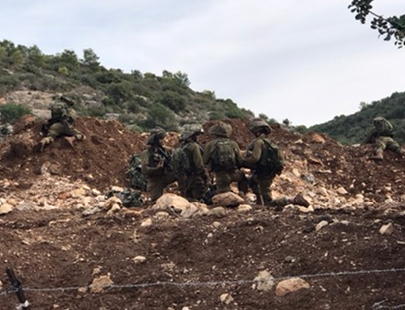 At one point we suddenly came across an IDF reconnaisance unit dug in to our left on a training mission. From the trees in the river valley in front of us there was a great deal of noise and shouting and we hurried on out of the firing line!


 We also continued to have fine views of the coast as the trail climbed ridges of higher ground from time to time between river valleys. The rocks were slippery where wet and sharp-edged – evidence of underwater volvanic activity when the Mediterranean Sea covered the area. Eventually, we arrived at Nahal Mearot an important pre-historic site with evidence of over 500,000 years of human activity with Human culture from the Acheulian (500,000 to 200,000 years ago), Mugharian (150,000 to 100,000 years ago), Mousterian (100,000 to 40,000 years ago), Aurignacian (40,000 to 12,000 years ago) and Natufian (12,000 to 9,000 years ago) eras.
 2012. They are protected within a

 We can measure the progress we are making by how much less time it now takes to reach the drop off point for the car. Kibbutz Yagur where we planned to finish the first day’s walk was barely an hour’s drive from my home and I met Rafi and Ronnie at the shopping mall just outside the kibbutz at 7:30am. Nowhere nearby for breakfast, so we grabbed something (and in my case snacks for lunch) at a pretty uninspiring petrol station on the way to the day’s start at Alon Hagalil.
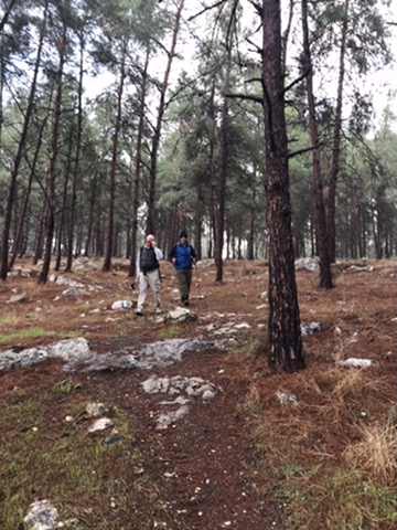 ran along the side of a field uphill to a forest where, after a short clamber over rocks the trail split. I could see INT markers over to the left and followed a quiet pine leaf covered trail upwards with occasional rocky out crops and markers every 25 metres or so. After perhaps 5 or 10 minutes I stopped for Ronnie and Rafi to catch up. They didn’t. After about 10 minutes I called; I called again; I blew my whistle. Silence reigned (apart from the occassional pair of F15s on manouevres). After a while I rang them on my mobile. It turned out they had turned right at the junction and lost the trail. I suggested they go back to the junction and turn left (rule 1 – if you lose your way on the trail, go back to the last marker you passed) but they decided to ‘save time’ going over a small hill to rejoin the trail on the other side.
 beside a stream to Hanezirim Mill (Monks’ Mill, owned by the Vatican). But even that was less than half way to Yagur, sunset was only 3 or so hours away and the weatehr showed signs of getting worse.

 for dinner. As we descended from the Carmel Mountains the nightime views of the city – as far as Akko – were spectacular.