‘FOURTEEN KILOMETRES! Is that ALL? What were you doing?’ I hear you ask. ‘It wasn’t even bad weather!’ Well, I’m not sure I can it explain either – except that terrain that looked pretty level on the map was anything but benign in reality.

Our first problem was, indeed, under-estimating the terrain (Rafi insisted his book called it an ‘easy day’). As we had decided to postpone the leg from Yagur to Nahal Oren to a later trip (because it involved a climb that was dangerous in the wet) we thought we had time for a leisurely breakfast at an Arcaffe in Haifa, left a car on Route 70 between Faradeis and Zichron Yaakov, and didn’t get under way from Nahal Oren until around 9:45am. But we didn’t really think too much of it with Rafi’s assurances ringing in our ears that this was going to be a easy day with around 22 km to cover in 6 or 7 hours.
We started with 169 steps up to the Etzba cave, but it was not a hard climb up to the entrance. Along the path is a small British post, which was constructed here during 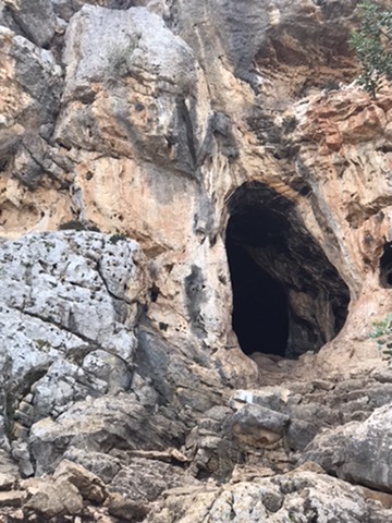 WWII in order to protect the entrance to Nahal Oren, one of the roads to the centre of the Carmel. This fortification was part of the “Masada” plan, conceived in order to make the “last stand” on Mount Carmel if German forces broke the British defence lines in Egypt. There are a number of British-mandate period structures in this area, such as on the west side of this ridge, and on other areas of Mount Carmel.
The cave is one of a number in the Oren valley inhabited by prehistoric man. Indeed, the Carmel Mountains are full of caves occupied by prehistoric man through several periods starting a half a million years ago up to around 9,000 years ago.
We were later to pass a fine museum giving much more detail – but were so far behind schedule we will need to go back another time. Nevertheless, at this stage the terrain was easy as we walked to Ein Hod and then turned due South parallel to the coast, with magnificant views out to the coast and beyond. 
From then on, however, the walking became increasingly slow. It wasn’t terribly difficult, but it was painstaking and arduous as the ground was broken and rocky; it was hard to make more than a couple of kilometres an hour. Frustratingly just a couple of hundred metres or so to our right was the coastal plain with smooth dirt roads and Route 4 – easy walking. But not for the first time the INT took a more challenging route, occasionally moving inland to take in the valleys carved by small streams running to the sea. Like good shvilists, we stuck to the trail.
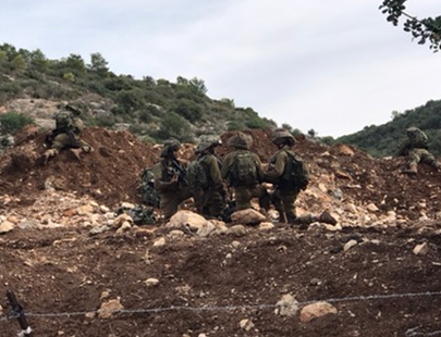 At one point we suddenly came across an IDF reconnaisance unit dug in to our left on a training mission. From the trees in the river valley in front of us there was a great deal of noise and shouting and we hurried on out of the firing line!
There were, surprisingly given the time of year, many more wild flowers than I had expected dotted among the rocks and adding colour to the patches of grass, and in the ptrotected valleys we could see bee hives.


 We also continued to have fine views of the coast as the trail climbed ridges of higher ground from time to time between river valleys. The rocks were slippery where wet and sharp-edged – evidence of underwater volvanic activity when the Mediterranean Sea covered the area. Eventually, we arrived at Nahal Mearot an important pre-historic site with evidence of over 500,000 years of human activity with Human culture from the Acheulian (500,000 to 200,000 years ago), Mugharian (150,000 to 100,000 years ago), Mousterian (100,000 to 40,000 years ago), Aurignacian (40,000 to 12,000 years ago) and Natufian (12,000 to 9,000 years ago) eras.
The Caves of Nahal Me’arot / Wadi el-Mughara (“Caves Creek”), are a UNESCO Site of Human Evolution. The four UNESCO-listed caves are:
- Tabun Cave or Tanur Cave (lit.: “Oven”)
- Gamal Cave or el-Jamal (“Camel”)
- el-Wad Cave or Nahal Cave (“Stream”)
- Es-Skhul Cave or Gedi Cave (“Kid”)
The four caves were proclaimed a site of “outstanding universal value” by UNESCO in  2012. They are protected within a nature reserve.
The caves were used for habitation by hominins and prehistoric humans and contain unique evidence of very early burials, at the archaeological site of el-Wad Cave in the Nahal Me’arot Nature Reserve.
We wanted to take time to see the museum but concluded that will need to be another trip. We had too far to go to the car to stop, so after a brief lunch and a drink at the museum cafe we pressed on.


We passed Sheikh Amir’s Tomb and later reached the Ofer lookout and observation tower. The views all around were magnificent. By now though it was clear we would not make the car before nightfall and we decided to stop at Route 7021, near Kerem Maharal, and to hike along the road west to Route 4 (where there was a petrol station marked on the map) and to call a taxi. So, that is what we did. By now the route was becoming easier and we made good time to the junction. The taxi came quickly and we made our way back to Beit Oren.
It was around then that Ronnie told me that Rafi had disclosed he made an error. The 22 km trek he had identified was easy enough to complete in the recommended time – but that time was 12 hours! We had less than 7 hours of daylight from when we started…
I then checked my maps. As you will see from the map for Stage 14 to 15, these actually only recommend doing the 14 km to Kerem Maharal in a normal hiking day because it is so arduous, especially in winter. I didn’t feel so bad then…
Thanks, Rafi!
